Aerial photographs in the assessment of physical and social change
Michael 2005; 2: 269–76.
Introduction
Arguments in public health work are often based on epidemiological studies of different kinds.
These may be longitudinal, so that the same objects of study are monitored over time. If the object of interest is linked to a geographical area, information of interest may be worked up by registration of noise, air pollution, automobile traffic etc. However, if longitudinal studies have human beings as their objects, the individuals have to be followed even if the dynamics of migration make them move to another area during the period of study.
Studies may also be cross-sectional, giving a picture of the situation just at the time when the research is performed. When data from, say, cross-sectional health surveys are combined with collected data on physical and social environment, positive or negative correlations may be established, but conclusions as to causality are seldom allowed. One of the main reasons for this is that health effects as a rule need time to manifest, and during this time both exposure and individuals at risk may have changed.
Despite the difficulties, appropriate methods for the assessment of health risks and causations in limited geographical areas, like in the part of a city or in a rural municipality are necessary, because the mechanisms going on may be more complicated to grasp and the findings more tricky to interpret than on a larger scale (1).
When looking around in a built-up area or enjoying the view of a landscape, you will often perceive the environment as something stable. If you stay away for a year or more, and then come back, you will be astonished that so many changes have taken place even in a relatively short time. Of importance for your private sphere is that shops you were familiar with have been replaced by others, the café at the corner is not there anymore, a factory has been converted into apartments, a previously open field has been filled with buildings etc. However, because major changes are not going on at the same time in all parts of an area, and because the developments are stepwise, the over-all process is not that visible and striking for those who are present every day. On the other hand, as a rule physical and social changes including demographic processes are linked together, and gradually the geographical area may convert itself into more or less a new society. The changes probably are even more important to the public sphere than to you. And to the epidemiologist and the social scientist, in this new situation old data lose in validity, at least as basis for practical public health work.
Even if statistics and maps, as a rule readily available in the planning departments of Norwegian municipalities, give good information on the changes, aerial photographs may be a useful supplement. Pictures taken from above add to the information in maps and statistical material because they also provide the same visual impressions which e.g. meet the person who has been away for a while, and may strike the mind in the same way and be useful for getting new ideas and new insights in public health work.
Material and methods
For Norway, aerial photographs of different kinds and with different dating are available in local archives and in the planning or geodata departments of municipalities. A private company, Fjellanger Widerøe Foto AS , offers aerial photographs of the whole of Norway, holds own archives back to 1935 and has taken over the archives of several other photographic firms. Vertical photogrammetric shots are used for mapping purposes etc., but for the assessment of changes in environment, oblique shots are often better, because they correspond to the way the world is perceived by the human eye. Both types are usually available.
When in an airplane, it is not difficult to the geographically interested or public health committed person to make the photographs herself or himself and catch just the shots of interest. A camera with a high quality lens is needed, and for analogue pictures a fine grain film should be selected. Colour material will often be best suited, but by using black and white film and an orange filter disturbing haze may be reduced, although details in green may appear too dark. Spring is the best time of the year, because by then there are not too many leaves on the trees. The aircraft should have a clear window, but minor faults may be compensated by setting the camera at a large aperture.
In this paper, a photograph taken by the author over central Oslo on May 3, 1992 is presented. The shot was made with a Leica camera equipped with a 50 mm Leitz Summilux 1,4 lens on Fuji HG 100 negative colour film. The picture here is about half of the negative frame. The negative digital scan at 1600 dpi was converted to black and white for printing purposes.
Comparison of photographs taken at different times is interesting, but not always necessary to analyse what has happened, e.g. in the built-up area on the picture for the 13 year period 1992–2005. The 2005 situation can be assessed by ground observation. However, if changes between two years back in time should be compared, a double set of pictures must be used.
Results
(The four letters A-D and the numbers 1–3 on the margins points to sections of the picture.)
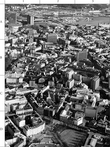
Central Oslo 1992 (Photo Ø. Larsen, file # 1320–24A 030592)
Section A1:
Physical changes: In «Gamlebyen» the noisy and polluting thoroughfare highway has been removed. The freight terminal has been closed down and replaced by a park.
Social changes: Housing areas have been upgraded.
Section A2:
Physical changes: Parts of the harbour and railway area have been converted into the so called «Medieval Park». A large hotel and a large office building has been erected southwest of the main railway station, and the opera building is under construction.
Social changes: The «Plata» gathering point for drug abusers and drug dealers has been cleared up. A lot of new workplaces have been introduced.
Section A3:
Physical changes: The old «Kvadraturen» part of the city has been upgraded with new museums and hotels, and apartments replace gradually some of the offices.
Social changes: This previous «dead» part of the city after working hours has become somewhat friendlier. However, still «sex workers» and their customers are found in some of the streets.
Section B1:
Physical changes: The previously decayed housing area «Meyerløkka» from the end of the 19th century has been upgraded to present day standards.
Social changes: Changes are following the conversion from low standard dwellings to attractive apartments.
Section B2:
Physical changes: «Meyerløkka», see above. Down right in this section is a part of the old National Hospital «Rikshospitalet» which has been converted into a large upmarket housing area. In the upper right corner of the section can be seen that the «Henrik Ibsen» office buildings are under construction.
Social changes: «Meyerløkka», see above. A large amount of workplaces in the «Rikshospitalet» have been moved away; on the other hand large numbers of new inhabitants are moving into the new apartments. Many new workplaces are found in the new office buildings.
Section B3:
Physical changes: The previous head quarter of the Telenor telecommunication company has been rebuilt, expanded and taken over by the Directorate of health and social affairs. The previous building of the Oslo city health authorities now belongs to the University of Oslo and is filled up with law students. The old building for the medical departments of the «Rikshospitalet» has been demolished and replaced by apartment blocks.
Social changes: Changes in the composition of the working population, and changes from a hospital and working area to a living area.
Section C1:
Physical changes: Up left can be seen the paediatric hospital, which has been torn down and replaced by a housing complex. Down left is a previous school, for long used as an office building, now converted and expanded to an apartment block. There have been few changes in the old housing area in the middle, apart from maintenance and upgrading.
Social changes: More inhabitants.
Section C2:
Physical changes: Up left the previous maternity clinic. This is by 2005 under conversion to a specialist clinic and offices for medical administration etc. Up right a large apartment block for nurses. This has been demolished and is under replacement by a new apartment block for the high-end market. Few changes are seen in the old-Berlin-style housing area from around 1890 in the middle, apart from maintenance and upgrading.
Social changes: Still not so many.
Section C3:
Physical changes: In the upper part of the section can be seen parts of the «Rikshospitalet», partly converted into living areas, but with the large pathology block still empty in 2005. In the lower part of this section is a part of the large Frydenlund Brewery, established 1859, now mostly demolished or rebuilt and taken over by the Oslo University College.
Social changes: Brewery employees have been replaced by students, and a working area has been converted to an academic campus.
Section D1:
Physical changes: Almost no changes.
Social changes: No significant changes.
Section D2:
Physical changes: Down left a part of the old Bislet sports arena, which in 2004–2005 is totally rebuilt. The park in the middle is by 2005 under rearrangement.
Social changes: No significant changes.
Section D3:
Physical changes: In the upper part of the section lies part of the former Frydenlund Brewery. The left part of the property has been rebuilt into a dense housing area with high standard flats. The buildings to the right are rebuilt for the Oslo University College. Lower part of the section: Service and shopping buildings, in decay in 1992 and still so in 2005.
Social changes: Many students and new inhabitants.
Discussion
By means of analysing a photograph like the one presented here, it can be seen that major physical and social changes have taken place in the course of a time as short as 13 years, here, however, mostly to the better. This could be taken as an exception, but is probably representative of the developments in Norway in general and in Oslo in particular during the 1990ies.
Looking at the picture may provoke many reflections. One of them is on how this district or even parts of it will function as a «place», as an environment for human life and activities. How are the conditions for geographical identification, for social cohesion and stability? A striking trait for the part of Oslo shown on the picture, is that a transformation of large parts of it into dense housing areas has been going on (especially in B2,B3,C2,C3,D3), and in other parts large scale rebuilding attracts new inhabitants (B1,B2). But still there are only one primary school on the picture, the private school of Saint Sunniva (B1) and one secondary school, the Oslo Cathedral School (B2). There are two churches, the Dome (A2) and the Trinity Church (B2), in addition to the Swedish church and the catholic church of Saint Olav (B1).
Natural arenas for social encounters are still scarce, and so are places for children to play. Although such facilities may be found outside the picture frames, the area inside the picture nevertheless is quite large, in fact larger than many a Norwegian regional city. Will the market driven construction of living areas risk to produce only a sort of transit places for people on the move in their housing career, leaving e.g. local networking as no issue of interest to the dwellers? Has the necessity for integration of functions and structures been sufficiently considered in the planning process?
When it comes to data available for analysis in the case of the example: If one should want to use statistical information, data on health parameters, on physical conditions etc. from the 1970-ies, 1980-ies or even the 1990-ies for the planning of public health activities in the region, it is quite clear that by 2005 the area contains another society, and that the relevance for the present situation for may data has to be questioned. This pertains to cross-sectional studies of environment and populations, but also to longitudinal studies, where the situation for noise, pollution etc. has become another and where the composition of the population working and living here has become different, if humans are object of study.
Epidemiology may easily become involuntary medical history if the rapid changes are not taken into consideration.
Conclusion
Of course photographs cannot replace other means of documentation, but they make changes very visible. Aerial photographs, especially taken at an oblique angle, may have special qualities as a basis for reflection, because they display the objects in a way which is in part familiar to the human eye, but at the same time gives a survey and puts the photographed objects into their geographical and social context. In the field of public health, aerial photographs may supplement the background data and stimulate ideas for interpretation of existing information, and for setting up new studies or implementing new public health ventures. The practical use of aerial photographs in public health work for studies of societal changes is therefore recommended.
Reference:
Elliot P, Cuzick J, English D, Stern R (eds.). Geographical and environmental epidemiology. Methods for small-area studies. Oxford/New York/Tokyo: Oxford University Press, 1992 (1997).
Professor of medical history
University of Oslo
Department of general practice and community medicine
P.O. Box 1130 Blindern
N-0318 Oslo, Norway
oivind.larsen@medisin.uio.no